 Value to Management
- Supports floodplain safety evaluation: Stream gage monitoring helps identify flood-prone areas, and detect changes in flow patterns that could be evidence of changes in land use or climate that increase flood risk.
- Provides data for water supply management: Information from monitoring contributes to drought and water supply management and planning, forming the basis for water resource management.
- Comprises an essential piece of water quality monitoring: Flow rates obtained from stream gages are essential to calculating overall pollutant loads, and supports development of water quality restoration plans and minimum flow standards.
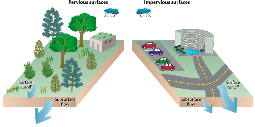
The volume of water flowing through Rhode Island’s rivers and streams is always changing—by season, with weather events, and over time—reflecting changes in water use, land use, and climate. Stream flows increase after rainfall as rainwater flows over land, into storm sewers, and through soils towards water bodies. It logically follows that stream flows increase during rainy seasons, rainy years, or due to changes in the landscape that modify how much water seeps into the ground and instead flows over the surface of the land, which increases the likelihood of flooding and decreases the natural action of water cleansing during its movement through soils.

Variations in stream flow are a critical aspect of the physical design of stream ecosystems. High flows have the power to shape the stream channel through eroding and depositing sediment, and clearing debris such as tree branches. High flows are also necessary to provide conditions that allow some fish species to travel upstream and spawn. Low flows also play an important ecosystem function. As flow decreases, the water level drops, and the area of stream bottom habitat decreases, which defines the smallest area potentially available to stream biota throughout the year. Low flows may also result in higher water temperatures, which typically have a negative impact on the native plants and animals that live there. Freshwater flows into the ocean are also very important to anadromous fish such as river herring, shad, and American eel that spend portions of their life cycles in both fresh and saltwater bodies.
Stream flow data have a wide breadth of application and are used by managers, watershed councils, and others. A few examples include: 1) flow information is critical to public safety; 2) is used by the National Weather Service to forecast floods, and 3) helps the Federal Emergency Management Agency (FEMA) identify flood prone areas. These predictions, in turn, are used to prevent people from building or developing in areas that are likely to be frequently flooded without approved adaptation: raised buildings, increase of ground level, or shoreline protection. As Rhode Island learned in 2010, floods have serious economic impacts: FEMA spent over $79 million to assist Rhode Island individuals and businesses following the historic flood of March 2010, and out-of-pocket expenses were equally impactful..

River and stream flow data are also essential to all aspects of water resource management. These data are used in drinking water supply, drought monitoring, and water pollution control management. They also support Total Maximum Daily Load (TMDL) analyses, which determine the allowable loadings of contaminants to a waterbody. Flow data are combined with measurements of the concentration of a chemical to estimate total pollutant loadings into a waterbody, and are integral to hydrodynamic and water quality modeling that is of critical use to state managers and researchers. Stream flow is also important in determining a stream’s suitability as wildlife habitat, as well as its suitability, value, and condition for recreational opportunities. If you are planning on kayaking one of Rhode Island’s scenic rivers, you need to know how high the water is running.

